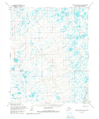
1955 Map of Beechey Point A-5
USGS Topo · Published 1982About this map
Ugnuravik River and the Sakonowyak River meander through this North Slope landscape, which was mapped by the Army Map Service during the mid-1950s. The region is characterized by a dense network of thaw lakes and ponds, typical of the Arctic coastal plain. While the area appears largely uninhabited on this survey, the presence of scattered Drill Holes and a solitary Drill Hole in the western and central sections indicates early energy exploration in the years before the major Prudhoe Bay discoveries. Along the eastern edge, the Kuparuk River flows toward the Arctic Ocean. These features are positioned within a grid of unsurveyed land lines predetermined by the Bureau of Land Management, reflecting a period when modern administrative boundaries were being imposed on a wilderness without established roads or trails.
Find a feature on this map
5 named features on this map. Tap any name to fly to it.
Don’t see what you’re looking for? This feature index may not catch every label — zoom into the map to look around manually.
Map Details
Editions of this 1955 Beechey Point A-5 Map
3 editions found
Other maps of this area

1951 · Harrison Bay
USGS Topo · 1:250,000

1951 · Beechey Point
USGS Topo · 1:250,000

1951 · Sagavanirktok D-5
USGS Topo · 1:250,000

1952 · Umiat
USGS Topo · 1:250,000

1955 · Harrison Bay
USGS Topo · 1:250,000

1955 · Beechey Point
USGS Topo · 1:250,000

1955 · Beechey Point B-4
USGS Topo · 1:63,360

1955 · Harrison Bay B-1
USGS Topo · 1:63,360

1955 · Beechey Point A-5
USGS Topo · 1:63,360

1955 · Beechey Point A-4
USGS Topo · 1:63,360