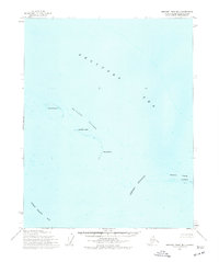
1955 Map of Beechey Point B-1
USGS Topo · Published 1977About this map
The Mc Clure Islands and Stockton Islands chain across the southern Beaufort Sea on this mid-century survey. Primarily a hydrographic and coastal study, the map records the delicate barrier island formations that shelter Foggy Island Bay from the open sea. Notable features include Narwhal Island, Jeanette Island, and Karluk Island, which form a natural breakwater. On Pole Island, the mapping of Ruins indicates a previous human presence or structure on these remote shores. This 1950s data, compiled from Army Map Service and USC&GS sources, documents the shoreline and bathymetry through the Newport Entrance before modern industrial developments shifted the landscape of the North Slope.
Find a feature on this map
10 named features on this map. Tap any name to fly to it.
Don’t see what you’re looking for? This feature index may not catch every label — zoom into the map to look around manually.
Map Details
Editions of this 1955 Beechey Point B-1 Map
2 editions found
Other maps of this area

1951 · Beechey Point
USGS Topo · 1:250,000

1955 · Flaxman Island
USGS Topo · 1:250,000

1955 · Beechey Point
USGS Topo · 1:250,000

1955 · Beechey Point B-2
USGS Topo · 1:63,360

1955 · Beechey Point B-1
USGS Topo · 1:63,360

1955 · Flaxman Island A-5
USGS Topo · 1:63,360

1955 · Beechey Point A-1
USGS Topo · 1:63,360

1955 · Beechey Point A-2
USGS Topo · 1:63,360
1955 · Flaxman Island B-5
USGS Topo · 1:63,360

1960 · Beechey Point
USGS Topo · 1:250,000