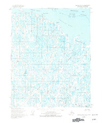
1955 Map of Beechey Point B-4
USGS Topo · Published 1977About this map
Beechey Point and the coastal marshes of the Kuparuk River Delta characterize this remote landscape along the Beaufort Sea. In the mid-1950s, the terrain was defined by a complex web of thaw lakes and braided waterways like the Sakonowyak River and the Kuparuk River. The presence of early industrial labels such as NW Eileen State No 1, West Kuparuk State No 1, and the Warehouse at Beechey Point indicates the nascent stages of exploration on the North Slope. These early state well sites predated the massive development of the Prudhoe Bay era, marking a period when the region was primarily accessible by air and sea via the Hull Landing Strip or through sheltered waters like Simpson Lagoon. Notable landforms such as Beechey Mound and Back Point provided rare vertical relief in an otherwise flat, water-dominated expanse.
Find a feature on this map
27 named features on this map. Tap any name to fly to it.
Don’t see what you’re looking for? This feature index may not catch every label — zoom into the map to look around manually.
Map Details
Editions of this 1955 Beechey Point B-4 Map
2 editions found
Other maps of this area

1951 · Beechey Point
USGS Topo · 1:250,000

1955 · Beechey Point
USGS Topo · 1:250,000
1955 · Beechey Point C-4
USGS Topo · 1:63,360

1955 · Beechey Point B-4
USGS Topo · 1:63,360

1955 · Beechey Point A-5
USGS Topo · 1:63,360

1955 · Beechey Point A-3
USGS Topo · 1:63,360

1955 · Beechey Point A-4
USGS Topo · 1:63,360
1955 · Beechey Point C-5
USGS Topo · 1:63,360

1955 · Beechey Point B-5
USGS Topo · 1:63,360

1955 · Beechey Point B-3
USGS Topo · 1:63,360