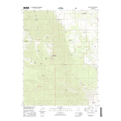
2017 Map of Beehive Peak
USGS Topo · Published 2017About this map
Fishlake National Forest defines the rugged verticality of this Sevier County landscape, where the high summits of Beehive Peak and Willow Creek Peak overlook a complex system of drainage canyons. The territory is marked by a network of historic transportation routes, including the Paiute (D-1) trail and the Richfield Pioneer road, suggesting the area's long-standing use for transit and resource management. Water is a scarce but vital element in this high-elevation terrain, found at Willow Creek Spring and flowing through Willow Creek and Pharo Creek. The map reveals the placement of several unique topographical features such as Ezras Flat, Frogs Flat, and Denmark Wash, alongside ridges like Mahogany Ridge and Nightgown Ridge. These names often reflect early local naming conventions or prominent pioneer families who navigated these canyons and spurs, including the Pharo-Willow Creek Peak Spur.
Find a feature on this map
53 named features on this map. Tap any name to fly to it.
Don’t see what you’re looking for? This feature index may not catch every label — zoom into the map to look around manually.
Map Details
Editions of this 2017 Beehive Peak Map
This is the sole edition of this map. No revisions or reprints were ever made.
Other maps of this area

1885 · Manti
USGS Topo · 1:250,000

1885 · Beaver
USGS Topo · 1:250,000

1885 · Sevier Desert
USGS Topo · 1:250,000

1885 · Fish Lake
USGS Topo · 1:250,000

1895 · Manti
USGS Topo · 1:250,000

1896 · Fish Lake
USGS Topo · 1:250,000

1953 · Richfield
USGS Topo · 1:250,000

1953 · Delta
USGS Topo · 1:250,000

1956 · Salina
USGS Topo · 1:250,000

1956 · Price
USGS Topo · 1:250,000