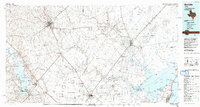
1985 Map of Beeville
USGS Topo · Published 1992About this map
The coastal plains of South Texas meet the gulf waters in this mid-1980s look at the region surrounding Beeville. This landscape is defined by the critical drainage systems of the Aransas River, Mission River, and Medio Creek that feed into the expansive Copano Bay. Along the coastline, the map documents the established community of Rockport and the nearby Goose Island State Park, providing a view of the coastal topography before modern expansion.
Find a feature on this map
131 named features on this map. Tap any name to fly to it.
Don’t see what you’re looking for? This feature index may not catch every label — zoom into the map to look around manually.
Map Details
Editions of this 1985 Beeville Map
2 editions found
Other maps of this area

1920 · Mikeska
USGS Topo · 1:125,000

1920 · San Diego
USGS Topo · 1:62,500

1925 · Oakville No. 4
USGS Topo · 1:48,000

1925 · Mathis No. 2
USGS Topo · 1:48,000

1925 · Robstown
USGS Topo · 1:62,500

1925 · Aransas Pass
USGS Topo · 1:62,500

1925 · Mathis No. 3
USGS Topo · 1:48,000

1925 · Corpus Christi
USGS Topo · 1:62,500

1927 · Mathis
USGS Topo · 1:62,500

1927 · Oakville
USGS Topo · 1:62,500