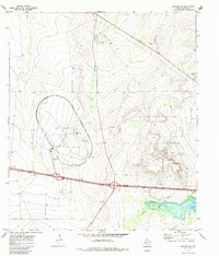
1970 Map of Belding NE
USGS Topo · Published 1985About this map
The Fort Stockton Oil and Gas Field dominates the landscape of this 1970 survey, illustrating the industrial footprint of the Permian Basin in Pecos County. The area is marked by a network of energy infrastructure, including an extensive Pipeline and numerous Oil Wells. Of particular interest is the large circular Test Facility near the center of the map, accompanied by an Observation Tower and the Chocatari landmark, suggesting a specialized technological or automotive proving ground.
Find a feature on this map
15 named features on this map. Tap any name to fly to it.
Don’t see what you’re looking for? This feature index may not catch every label — zoom into the map to look around manually.
Map Details
Editions of this 1970 Belding NE Map
This is the sole edition of this map. No revisions or reprints were ever made.
Other maps of this area

1921 · Fort Stockton
USGS Topo · 1:62,500

1923 · Fort Stockton
USGS Topo · 1:62,500

1928 · Comanche Spring
USGS Topo · 1:125,000

1929 · Hovey
USGS Topo · 1:125,000

1931 · Barstow
USGS Topo · 1:125,000

1954 · Pecos
USGS Topo · 1:250,000

1954 · Fort Stockton
USGS Topo · 1:250,000

1957 · Pecos
USGS Topo · 1:250,000

1958 · Fort Stockton
USGS Topo · 1:250,000

1970 · Belding SW
USGS Topo · 1:24,000