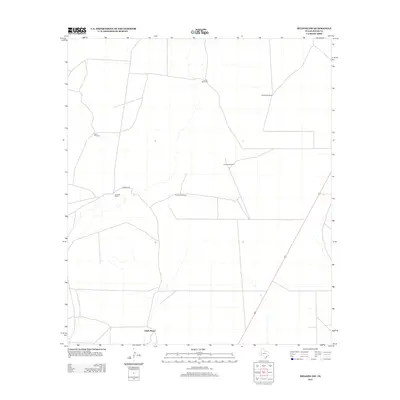
2012 Map of Belding SW
USGS Topo · Published 2012About this map
Smith Place and the Kennedy Ranch define the dispersed settlement pattern of this Pecos County landscape during the early twenty-first century. The area is characterized by an extensive network of water infrastructure essential for ranching, marked by numerous named wells including Llano Windmill, Brahma Windmill, and Fortyfoot Windmill. Transportation is largely confined to unimproved paths and the primary artery of Kennedy Rd, which provides access through the expansive rangeland. This survey captures a moment in the modern management of West Texas territory, where the placement of landmarks like Tanquary Windmill and Bond Windmill continues to dictate the local geography and logistics of land use in a region where water sources serve as the primary navigational anchors.
Find a feature on this map
8 named features on this map. Tap any name to fly to it.
Don’t see what you’re looking for? This feature index may not catch every label — zoom into the map to look around manually.
Map Details
Editions of this 2012 Belding SW Map
This is the sole edition of this map. No revisions or reprints were ever made.
Other maps of this area

1929 · Hovey
USGS Topo · 1:125,000

1954 · Fort Stockton
USGS Topo · 1:250,000

1958 · Fort Stockton
USGS Topo · 1:250,000

1970 · Belding SW
USGS Topo · 1:24,000

1970 · Tucker Hill
USGS Topo · 1:24,000

1970 · Deep Well Ranch SE
USGS Topo · 1:24,000

1970 · Belding NW
USGS Topo · 1:24,000
1970 · Belding NE
USGS Topo · 1:24,000
1970 · Belding
USGS Topo · 1:24,000

1973 · Fort Stockton
USGS Topo · 1:250,000