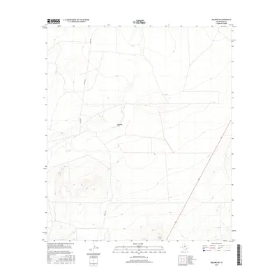
2016 Map of Belding SW
USGS Topo · Published 2016About this map
Coyanosa Draw carves a path through the arid landscape of Pecos County, serving as the primary drainage feature in this corner of the Trans-Pecos. The terrain is defined by dramatic elevation changes, where high-relief ridges overlook broad alluvial basins. Human infrastructure remains sparse, concentrated along Kennedy Rd, which provides north-south access through the shifting elevations of the West Texas scrubland. This 2016 survey illustrates the balance of topographical complexity and open range, where modern roadway corridors trace the contours of a region still primarily shaped by water erosion and ranching history. The map offers a clear view of the land's physical layout before further development or landscape changes affect this rural pocket near the Smith Place area.
Find a feature on this map
2 named features on this map. Tap any name to fly to it.
Don’t see what you’re looking for? This feature index may not catch every label — zoom into the map to look around manually.
Map Details
Editions of this 2016 Belding SW Map
This is the sole edition of this map. No revisions or reprints were ever made.
Other maps of this area

1929 · Hovey
USGS Topo · 1:125,000

1954 · Fort Stockton
USGS Topo · 1:250,000

1958 · Fort Stockton
USGS Topo · 1:250,000

1970 · Belding SW
USGS Topo · 1:24,000

1970 · Tucker Hill
USGS Topo · 1:24,000

1970 · Deep Well Ranch SE
USGS Topo · 1:24,000

1970 · Belding NW
USGS Topo · 1:24,000
1970 · Belding NE
USGS Topo · 1:24,000
1970 · Belding
USGS Topo · 1:24,000

1973 · Fort Stockton
USGS Topo · 1:250,000