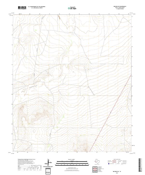
2022 Map of Belding SW
USGS Topo · Published 2022About this map
Coyanosa Draw meanders across this West Texas landscape, defining the topography of an area largely shaped by natural drainage and high-desert relief. In this corner of Pecos County, human development is sparse, primarily represented by the linear path of Highway 67 slicing through the eastern portion of the quadrangle and the unpaved route of Kennedy Rd. The map illustrates a transitional terrain where relatively flat plains give way to more complex, elevated landforms in the southwest. This topographic study reflects the modern character of the region, where the primary infrastructure serves as a corridor through the vast, open spaces between more populated centers of the Trans-Pecos.
Find a feature on this map
3 named features on this map. Tap any name to fly to it.
Don’t see what you’re looking for? This feature index may not catch every label — zoom into the map to look around manually.
Map Details
Editions of this 2022 Belding SW Map
This is the sole edition of this map. No revisions or reprints were ever made.
Other maps of this area

1929 · Hovey
USGS Topo · 1:125,000

1954 · Fort Stockton
USGS Topo · 1:250,000

1958 · Fort Stockton
USGS Topo · 1:250,000

1970 · Belding SW
USGS Topo · 1:24,000

1970 · Tucker Hill
USGS Topo · 1:24,000

1970 · Deep Well Ranch SE
USGS Topo · 1:24,000

1970 · Belding NW
USGS Topo · 1:24,000
1970 · Belding NE
USGS Topo · 1:24,000
1970 · Belding
USGS Topo · 1:24,000

1973 · Fort Stockton
USGS Topo · 1:250,000