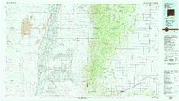
1979 Map of Belen
USGS Topo · Published 1979About this map
Rio Grande waters define the valley floor where historic communities like Los Lunas and Belen sit alongside the Atchison Topeka and Santa Fe RR. This 1979 survey illustrates a landscape of stark contrasts, from the sprawling Isleta Indian Reservation and Kirtland Air Force Base in the north to the dense contours of the Cibola National Forest covering the Manzano Mountains. Significant late-century land developments are evident in the geometric grids of Rio Grande Estates and Meadow Lake, marking a period of suburban transition into the high desert. To the east, the terrain levels out into the expansive Mesa de los Jumanos, where smaller settlements like Mountainair and Willard serve as hubs for the surrounding ranching and transit corridors.
Find a feature on this map
85 named features on this map. Tap any name to fly to it.
Don’t see what you’re looking for? This feature index may not catch every label — zoom into the map to look around manually.
Map Details
Editions of this 1979 Belen Map
2 editions found
Other maps of this area

1883 · Mt. Taylor
USGS Topo · 1:250,000

1886 · Mt. Taylor
USGS Topo · 1:250,000

1888 · Bernalillo
USGS Topo · 1:125,000

1889 · Albuquerque
USGS Topo · 1:125,000

1892 · San Pedro
USGS Topo · 1:125,000

1892 · Mt. Taylor
USGS Topo · 1:250,000

1893 · Albuquerque
USGS Topo · 1:125,000

1894 · Lamy
USGS Topo · 1:125,000

1899 · Mt. Taylor
USGS Topo · 1:250,000

1916 · La Joya
USGS Topo · 1:125,000