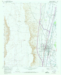
1952 Map of Belen
USGS Topo · Published 1973About this map
The Nicolas Duran de Chavez Grant and Belen Grant define the landscape of the Middle Rio Grande Valley as it appeared in the mid-20th century. The settlement of Belen serves as the central hub, supported by smaller communities like Los Chavez and Los Trujillos. This era shows an intricate irrigation and drainage system critical to valley agriculture, featuring the Belen High Line Canal, Old Jarales Ditch, and Gabaldon Levee.
Find a feature on this map
32 named features on this map. Tap any name to fly to it.
Don’t see what you’re looking for? This feature index may not catch every label — zoom into the map to look around manually.
Map Details
Editions of this 1952 Belen Map
3 editions found
Other maps of this area

1952 · Dalies
USGS Topo · 1:24,000

1952 · Belen SW
USGS Topo · 1:24,000

1952 · Belen
USGS Topo · 1:24,000

1952 · Turn
USGS Topo · 1:24,000

1952 · Veguita
USGS Topo · 1:24,000

1952 · Belen NW
USGS Topo · 1:24,000

1952 · Rio Puerco
USGS Topo · 1:24,000

1952 · Tome
USGS Topo · 1:24,000

1952 · Los Lunas
USGS Topo · 1:24,000

1954 · Socorro
USGS Topo · 1:250,000