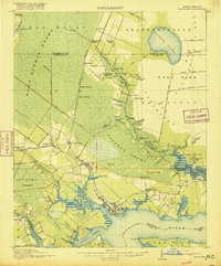
1916 Map of Belhaven
USGS Topo · Published 1916About this map
The coastal plains of Beaufort and Hyde counties are dominated here by the expansive East Dismal Swamp and Pantego Swamp, revealing a landscape undergoing intensive drainage and lumbering at the start of the 20th century. The Norfolk Southern RR and a dedicated Lumber RR penetrate the wetlands, connecting remote sidings like Sixteenmile Siding and Johnson Siding to the port at Belhaven. The map documents a transition from wild marsh to managed timberland, marked by an intricate network of canals including the Intercepting Canal and Broad Creek Canal.
Find a feature on this map
88 named features on this map. Tap any name to fly to it.
Don’t see what you’re looking for? This feature index may not catch every label — zoom into the map to look around manually.
Map Details
Editions of this 1916 Belhaven Map
3 editions found
Other maps of this area

1914 · Belhaven
USGS Topo · 1:48,000

1916 · Belhaven
USGS Topo · 1:62,500

1943 · Columbia
USGS Topo · 1:125,000

1943 · Plymouth
USGS Topo · 1:125,000

1950 · Pinetown
USGS Topo · 1:24,000

1951 · Bath
USGS Topo · 1:24,000

1951 · Ransomville
USGS Topo · 1:24,000

1951 · Pamlico Beach
USGS Topo · 1:24,000

1951 · Belhaven
USGS Topo · 1:24,000

1951 · Pantego
USGS Topo · 1:24,000