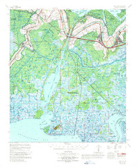
1967 Map of Belle Isle
USGS Topo · Published 1969About this map
Patterson and the winding Bayou Teche dominate the northeastern corner of this coastal Louisiana survey, where the Southern Pacific railroad and Highway 90 bridge the waterway. The landscape is defined by the transition from settled levee lands to the expansive marsh systems of the Wax Lake and Atchafalaya Bay regions. Significant industrial activity is evident throughout the wetlands, particularly within the Belle Isle Gas and Oil Field and the Garden City Oil and Gas Field, showing the infrastructure of the mid-century energy economy. The Intracoastal Waterway cuts a straight path through the maze of natural channels like Bear Bayou and Possum Point Bayou, serving as a vital artery for maritime commerce. Cultural landmarks such as the Little Zion Church near Shadyside and various cemeteries provide grounding for genealogical research in this specialized riverine environment.
Find a feature on this map
62 named features on this map. Tap any name to fly to it.
Don’t see what you’re looking for? This feature index may not catch every label — zoom into the map to look around manually.
Map Details
Editions of this 1967 Belle Isle Map
This is the sole edition of this map. No revisions or reprints were ever made.
Other maps of this area

1932 · Lake Decade
USGS Topo · 1:62,500

1935 · Belle Isle
USGS Topo · 1:31,680

1935 · Morgan City
USGS Topo · 1:62,500

1937 · Bayou Sale
USGS Topo · 1:62,500

1937 · Jeanerette
USGS Topo · 1:62,500

1941 · Belle Isle
USGS Topo · 1:62,500

1945 · New Orleans
USGS Topo · 1:250,000

1948 · Foster
USGS Topo · 1:62,500

1953 · Napoleonville
USGS Topo · 1:62,500

1954 · Morgan City
USGS Topo · 1:62,500