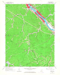
1965 Map of Belle
USGS Topo · Published 1966About this map
The Kanawha River corridor serves as the industrial and transportation spine of this region during the mid-1960s, with settlements like Marmet, Belle, and Chesapeake concentrated along the water and the West Virginia Turnpike. This landscape is defined by the extraction economy of the Appalachian coalfields, where numerous mines, strip mines, and tipples are tucked into the hollows of the Loudon and Cabin Creek districts.
Find a feature on this map
78 named features on this map. Tap any name to fly to it.
Don’t see what you’re looking for? This feature index may not catch every label — zoom into the map to look around manually.
Map Details
Editions of this 1965 Belle Map
4 editions found
Other maps of this area

1897 · Kanawha Falls
USGS Topo · 1:125,000

1899 · Charleston
USGS Topo · 1:125,000

1900 · Kanawha Falls
USGS Topo · 1:125,000

1901 · Kanawha Falls
USGS Topo · 1:125,000

1907 · Clendenin
USGS Topo · 1:62,500

1908 · Montgomery
USGS Topo · 1:48,000

1909 · Charleston
USGS Topo · 1:62,500

1909 · Clendenin
USGS Topo · 1:62,500

1909 · Peytona
USGS Topo · 1:48,000

1910 · Montgomery
USGS Topo · 1:62,500