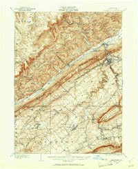
1908 Map of Bellefonte
USGS Topo · Published 1961About this map
Pennsylvania State College and the surrounding agricultural valleys of Central Pennsylvania are captured here at the turn of the century. The map illustrates a landscape defined by the parallel ridges of Bald Eagle Mountain and the Snow Shoe Mountains, with the Nittany Valley serving as a corridor for the Pennsylvania RR and the Lewisburg and Tyrone RR. The county seat of Bellefonte stands as a primary hub, while smaller post offices like Scotia Benore PO and Unionville Fleming PO mark the distribution of rural life.
Find a feature on this map
75 named features on this map. Tap any name to fly to it.
Don’t see what you’re looking for? This feature index may not catch every label — zoom into the map to look around manually.
Map Details
Editions of this 1908 Bellefonte Map
3 editions found
Other maps of this area

1908 · Bellefonte
USGS Topo · 1:62,500

1909 · Bellefonte
USGS Topo · 1:62,500

1919 · Menno
USGS Topo · 1:62,500

1921 · Howard
USGS Topo · 1:48,000

1922 · Philipsburg
USGS Topo · 1:62,500

1923 · Howard
USGS Topo · 1:62,500

1923 · Tyrone
USGS Topo · 1:62,500

1924 · Centre Hall
USGS Topo · 1:62,500

1924 · Lewistown
USGS Topo · 1:62,500

1927 · Lewisburg
USGS Topo · 1:62,500