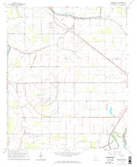
1965 Map of Bellewood
USGS Topo · Published 1966About this map
The Yazoo River defines the southeastern corner of this delta landscape, which is marked by a complex network of seasonal waterways including Jackson Bayou, Buck Bayou, and Little Atchafalaya Bayou. The Illinois Central railroad cuts a diagonal path through the terrain, serving the small agricultural hubs of Bellewood and Castleman. This mid-1960s survey reveals a dispersed rural community organized around small gathering points like Zion Traveler Ch, Daybreak Chapel, and the Mount Carmel Sch.
Find a feature on this map
32 named features on this map. Tap any name to fly to it.
Don’t see what you’re looking for? This feature index may not catch every label — zoom into the map to look around manually.
Map Details
Editions of this 1965 Bellewood Map
2 editions found
Other maps of this area

1940 · Auter
USGS Topo · 1:62,500

1940 · Baird
USGS Topo · 1:62,500

1940 · Mileston
USGS Topo · 1:62,500

1953 · Greenwood
USGS Topo · 1:250,000

1954 · Mileston
USGS Topo · 1:62,500

1956 · Greenwood
USGS Topo · 1:250,000

1961 · Mossy Lake
USGS Topo · 1:62,500
1965 · Richey
USGS Topo · 1:24,000
1965 · Midnight
USGS Topo · 1:24,000

1965 · Inverness
USGS Topo · 1:24,000