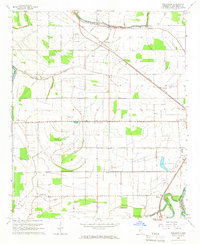
1965 Map of Bellewood
USGS Topo · Published 1966About this map
The Illinois Central railroad cuts diagonally across this Delta landscape, anchoring the settlements of Bellewood and Castleman. The terrain is defined by a dense network of meandering waterways, including Jackson Bayou and Tupper Bayou, which influence the placement of agricultural fields and roads. In the southeast corner, the Yazoo River loops near the community of Hard Cash, where a Lookout Tower and the Belzoni Municipal Airport are situated.
Find a feature on this map
30 named features on this map. Tap any name to fly to it.
Don’t see what you’re looking for? This feature index may not catch every label — zoom into the map to look around manually.
Map Details
Editions of this 1965 Bellewood Map
2 editions found
Other maps of this area

1940 · Auter
USGS Topo · 1:62,500

1940 · Baird
USGS Topo · 1:62,500

1940 · Mileston
USGS Topo · 1:62,500

1953 · Greenwood
USGS Topo · 1:250,000

1954 · Mileston
USGS Topo · 1:62,500

1956 · Greenwood
USGS Topo · 1:250,000

1961 · Mossy Lake
USGS Topo · 1:62,500
1965 · Richey
USGS Topo · 1:24,000
1965 · Midnight
USGS Topo · 1:24,000

1965 · Inverness
USGS Topo · 1:24,000