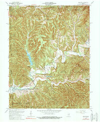
1966 Map of Belmont
USGS Topo · Published 1984About this map
Belmont and the surrounding timberlands of Brown County appear as they were in the mid-1960s, a period when reforestation and conservation efforts had fully matured into the Yellowwood State Forest and Hoosier National Forest. The landscape is dominated by the dendritic drainage of Salt Creek, with Yellowwood Lake and Somerset Lake providing focal points for local recreation. The map reveals the intricate network of ridge-top roads and hollows, including Lanam Ridge Road and Yellowwood Road, which connect rural enclaves and family sites like Lanam Cem.
Find a feature on this map
84 named features on this map. Tap any name to fly to it.
Don’t see what you’re looking for? This feature index may not catch every label — zoom into the map to look around manually.
Map Details
Editions of this 1966 Belmont Map
4 editions found
Other maps of this area

1942 · Franklin
USGS Topo · 1:125,000

1946 · Belmont
USGS Topo · 1:24,000

1947 · Allens Creek
USGS Topo · 1:24,000

1947 · Unionville
USGS Topo · 1:24,000

1947 · Nashville
USGS Topo · 1:24,000

1947 · Elkinsville
USGS Topo · 1:24,000

1947 · Franklin
USGS Topo · 1:62,500

1948 · Hindustan
USGS Topo · 1:24,000

1948 · Fruitdale
USGS Topo · 1:24,000

1948 · Morgantown
USGS Topo · 1:24,000