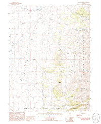
1985 Map of Belmont Creek
USGS Topo · Published 1986About this map
Huntington Valley serves as the central corridor for this mid-1980s landscape, where established family holdings like Twin Creek Ranch and Sadler Ranch mark the western flats. The terrain rises sharply to the east into the Ruby Mountains and the Humboldt National Forest, a transition defined by a complex network of seasonal drainages and springs. The map reveals a reliance on isolated water sources for ranching and survival, with named points such as Hellman Spring, White Pine Well, and School Creek Spring scattered throughout the foothills. To the south, the Elko and White Pine county line crosses the mountain slopes, while evidence of localized excavation appears at several Gravel Pits near Belmont Creek. This survey captures the remote character of northeastern Nevada, where geography is dictated by the availability of water and the high-elevation forest boundary.
Find a feature on this map
28 named features on this map. Tap any name to fly to it.
Don’t see what you’re looking for? This feature index may not catch every label — zoom into the map to look around manually.
Map Details
Editions of this 1985 Belmont Creek Map
This is the sole edition of this map. No revisions or reprints were ever made.
Other maps of this area

1934 · Jiggs
USGS Topo · 1:125,000

1937 · Jiggs
USGS Topo · 1:125,000

1955 · Elko
USGS Topo · 1:250,000

1956 · Robinson Mtn
USGS Topo · 1:62,500

1958 · Elko
USGS Topo · 1:250,000

1959 · Jiggs
USGS Topo · 1:62,500

1959 · Railroad Pass
USGS Topo · 1:62,500

1959 · Sherman Mtn
USGS Topo · 1:62,500

1962 · Elko
USGS Topo · 1:250,000

1965 · Elko
USGS Topo · 1:250,000