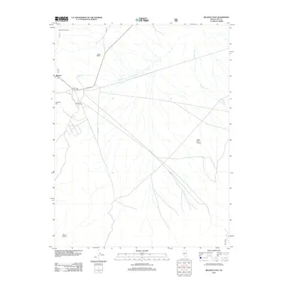
2012 Map of Belmont East
USGS Topo · Published 2012About this map
Belmont serves as the primary landmark on this eastern Nye County landscape, situated near the intersection of State Hwy 82 and NFD 230 Rd. The industrial heritage of the area is evident through the presence of the Combination Mill and Highbridge Mill, located just south of the main settlement. These sites, coupled with the nearby Combination Spring, suggest a history tied to resource extraction and processing in the high desert terrain.
Find a feature on this map
12 named features on this map. Tap any name to fly to it.
Don’t see what you’re looking for? This feature index may not catch every label — zoom into the map to look around manually.
Map Details
Editions of this 2012 Belmont East Map
This is the sole edition of this map. No revisions or reprints were ever made.
Other maps of this area

1956 · Tonopah
USGS Topo · 1:250,000

1959 · Tonopah
USGS Topo · 1:250,000

1962 · Tonopah
USGS Topo · 1:250,000

1971 · Belmont East
USGS Topo · 1:24,000

1971 · Corcoran Canyon
USGS Topo · 1:24,000

1971 · Barley Creek
USGS Topo · 1:24,000
1971 · Elkhorn Canyon
USGS Topo · 1:24,000

1971 · Belmont West
USGS Topo · 1:24,000

1971 · Jefferson
USGS Topo · 1:24,000
1971 · McCann Canyon
USGS Topo · 1:24,000