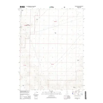
2014 Map of Belmont East
USGS Topo · Published 2014About this map
Belmont and the surrounding high desert of Nye County are mapped here during the early 21st century, revealing a landscape defined by sharp elevation shifts and traditional water sources. The settlement sits on the western edge of the sheet, tucked against the Toiyabe National Forest boundary. Local history is anchored at Cem Hill, while the rugged hydrology of the region is marked by Combination Spring and the ephemeral drainage of Wattles Cr. The terrain transitions from the broad expanse of Monitor Valley in the north to the uplifted reaches of the McKinney Mountains in the south. Several distinct landmarks punctuate the topography, including the high points of Black Buttes and the descriptively named Horse Heaven, alongside deep cuts through the rock at Snowbird Canyon and White Rock Canyon.
Find a feature on this map
19 named features on this map. Tap any name to fly to it.
Don’t see what you’re looking for? This feature index may not catch every label — zoom into the map to look around manually.
Map Details
Editions of this 2014 Belmont East Map
This is the sole edition of this map. No revisions or reprints were ever made.
Other maps of this area

1956 · Tonopah
USGS Topo · 1:250,000

1959 · Tonopah
USGS Topo · 1:250,000

1962 · Tonopah
USGS Topo · 1:250,000

1971 · Belmont East
USGS Topo · 1:24,000

1971 · Corcoran Canyon
USGS Topo · 1:24,000

1971 · Barley Creek
USGS Topo · 1:24,000
1971 · Elkhorn Canyon
USGS Topo · 1:24,000

1971 · Belmont West
USGS Topo · 1:24,000

1971 · Jefferson
USGS Topo · 1:24,000
1971 · McCann Canyon
USGS Topo · 1:24,000