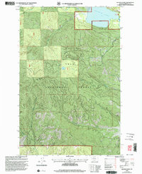
1999 Map of Belmont Point
USGS Topo · Published 2000About this map
Lolo National Forest dominates this topographic landscape, where the high-altitude terrain of the Game Ridge and Belmont Point defines the watershed for numerous mountain tributaries. The northeastern corner of the map features the recreational and ecological anchor of Placid Lake, managed in part by the Seeley Lake Ranger District. This area, updated in the late 1990s, reveals a dense network of forest drainage systems, including Placid Creek and Finley Creek, which navigate the steep gradients of the Missoula County back-country.
Find a feature on this map
20 named features on this map. Tap any name to fly to it.
Don’t see what you’re looking for? This feature index may not catch every label — zoom into the map to look around manually.
Map Details
Editions of this 1999 Belmont Point Map
This is the sole edition of this map. No revisions or reprints were ever made.
Other maps of this area

1902 · Ovando
USGS Topo · 1:125,000

1903 · Bonner
USGS Topo · 1:125,000

1905 · Ovando
USGS Topo · 1:125,000

1919 · Drummond
USGS Topo · 1:125,000

1921 · Drummond
USGS Topo · 1:125,000

1921 · Elbow Lake
USGS Topo · 1:125,000

1947 · Butte
USGS Topo · 1:250,000

1955 · Choteau
USGS Topo · 1:250,000

1957 · Choteau
USGS Topo · 1:250,000

1958 · Butte
USGS Topo · 1:250,000