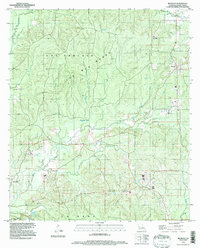
1994 Map of Belmont
USGS Topo · Published 1997About this map
Las Hormigas Woods and The Big Woods dominate the rolling topography of this Sabine Parish landscape, as mapped during the mid-1990s. The settlement of Belmont sits at a crossroads in the northeastern quadrant, while the northern edge of Zwolle appears in the southwest, connected by a network of rural routes and timber-access roads. This area is defined by its complex drainage systems, where San Miguel Creek and White Lick Creek navigate through densely wooded terrain.
Find a feature on this map
16 named features on this map. Tap any name to fly to it.
Don’t see what you’re looking for? This feature index may not catch every label — zoom into the map to look around manually.
Map Details
Editions of this 1994 Belmont Map
This is the sole edition of this map. No revisions or reprints were ever made.
Other maps of this area

1938 · Hollis Creek
USGS Topo · 1:31,680

1941 · Zwolle
USGS Topo · 1:62,500

1941 · Pelican
USGS Topo · 1:62,500

1942 · Many
USGS Topo · 1:62,500

1943 · Many
USGS Topo · 1:62,500

1943 · Pleasant Hill
USGS Topo · 1:62,500

1944 · Zwolle
USGS Topo · 1:62,500

1944 · Pleasant Hill
USGS Topo · 1:62,500

1947 · Hanna
USGS Topo · 1:62,500

1953 · Alexandria
USGS Topo · 1:250,000