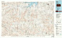
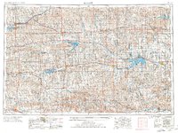
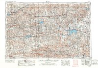
1955 Map of Beloit
USGS Topo · Published 1971This historical map portrays the area of Beloit in 1955, primarily covering Mitchell County as well as portions of Graham County, Ellis County, Russell County, Norton, Phillips County, Rooks County, Smith County, Osborne County, Lincoln County, Jewell County, and Trego County. Featuring a scale of 1:250000, this map provides a highly detailed snapshot of the terrain, roads, buildings, counties, and historical landmarks in the Beloit region at the time. Published in 1971, it is one of 3 known editions of this map due to revisions or reprints.
Find a feature on this map
107 named features on this map. Tap any name to fly to it.
Don’t see what you’re looking for? This feature index may not catch every label — zoom into the map to look around manually.
Map Details
Editions of this 1955 Beloit Map
3 editions found
Historical Maps of Portis Through Time
5 maps found