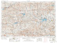
1955 Map of Beloit
USGS Topo · Published 1977About this map
The Solomon River and its major tributaries, the North Fork Solomon River and South Fork Solomon River, carve a distinct path across this mid-century landscape. This era represents a significant period of water management in north-central Kansas, as evidenced by the large-scale impoundments at the Kirwin Reservoir and Webster Reservoir, alongside the newly designated Glen Elder Res. These projects shifted the local economy from traditional riverfront agriculture toward the recreation and conservation seen at Kirwin National Wildlife Refuge and various state parks.
Find a feature on this map
102 named features on this map. Tap any name to fly to it.
Don’t see what you’re looking for? This feature index may not catch every label — zoom into the map to look around manually.
Map Details
Editions of this 1955 Beloit Map
3 editions found

Other maps of this area

1892 · Concordia
USGS Topo · 1:125,000

1892 · Salina
USGS Topo · 1:125,000

1892 · Minneapolis
USGS Topo · 1:125,000

1893 · Ellis
USGS Topo · 1:125,000

1893 · Smith Center
USGS Topo · 1:125,000

1893 · Norton
USGS Topo · 1:125,000

1893 · Phillipsburg
USGS Topo · 1:125,000

1893 · Hill
USGS Topo · 1:125,000

1894 · Ellsworth
USGS Topo · 1:125,000

1894 · Mankato
USGS Topo · 1:125,000