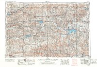
1955 Map of Beloit
USGS Topo · Published 1987About this map
Nicodemus stands as a notable landmark in this north-central Kansas landscape, reflecting the heritage of the Post-Civil War era. The region is defined by the branching tributaries of the Solomon River and the Saline River, where water management projects have reshaped the terrain into significant catchment areas. These include the Kirwin Reservoir and Webster Reservoir, which provide both irrigation and habitat within the Kirwin National Wildlife Refuge. The settlement pattern follows the established rail corridors of the Chicago Rock Island and Pacific and the Missouri Pacific, connecting towns like Phillipsburg, Smith Center, and Beloit. Large-scale recreation is prominent at Glen Elder State Park and Lovewell State Park, where the impoundment of water has created focal points for the surrounding rural communities. This survey documents the intersection of agricultural transport networks and the mid-century expansion of state-managed water resources.
Find a feature on this map
87 named features on this map. Tap any name to fly to it.
Don’t see what you’re looking for? This feature index may not catch every label — zoom into the map to look around manually.
Map Details
Editions of this 1955 Beloit Map
3 editions found

Other maps of this area

1892 · Concordia
USGS Topo · 1:125,000

1892 · Salina
USGS Topo · 1:125,000

1892 · Minneapolis
USGS Topo · 1:125,000

1893 · Ellis
USGS Topo · 1:125,000

1893 · Smith Center
USGS Topo · 1:125,000

1893 · Norton
USGS Topo · 1:125,000

1893 · Phillipsburg
USGS Topo · 1:125,000

1893 · Hill
USGS Topo · 1:125,000

1894 · Ellsworth
USGS Topo · 1:125,000

1894 · Mankato
USGS Topo · 1:125,000