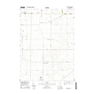
2015 Map of Belvidere NE
USGS Topo · Published 2015About this map
Poplar Grove serves as the primary hub of this landscape where the Illinois prairie meets the Wisconsin border. The geography is defined by a series of north-south and east-west roads that trace the original sections, including Poplar Grove Rd and Manchester Rd. Small agricultural hamlets like Blaine, Hunter, and Beaverton Crossroads anchor the surrounding farmland, while the presence of Stone School Cem and Tound Prairie Cem offer significant points of interest for those researching local pioneer genealogy.
Find a feature on this map
41 named features on this map. Tap any name to fly to it.
Don’t see what you’re looking for? This feature index may not catch every label — zoom into the map to look around manually.
Map Details
Editions of this 2015 Belvidere NE Map
This is the sole edition of this map. No revisions or reprints were ever made.
Other maps of this area

1893 · Delavan
USGS Topo · 1:62,500

1893 · Shopiere
USGS Topo · 1:62,500

1918 · Belvidere
USGS Topo · 1:62,500

1932 · Harvard
USGS Topo · 1:48,000

1937 · Harvard
USGS Topo · 1:62,500

1944 · Belvidere
USGS Topo · 1:62,500

1954 · Rockford
USGS Topo · 1:250,000

1955 · Rockford
USGS Topo · 1:250,000

1958 · Rockford
USGS Topo · 1:250,000
1960 · Delavan
USGS Topo · 1:62,500