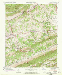
1947 Map of Ben Hur
USGS Topo · Published 1970About this map
The Lonesome Pine Trail and the Daniel Boone Trail intersect the ridges of Lee County in this landscape, where the Louisville and Nashville railroad tracks follow the winding course of Cane Creek. The topography is dominated by parallel ridges including Stone Mountain and Powell Mountain, with the Powell River carving deep meanders between them.
Find a feature on this map
76 named features on this map. Tap any name to fly to it.
Don’t see what you’re looking for? This feature index may not catch every label — zoom into the map to look around manually.
Map Details
Editions of this 1947 Ben Hur Map
4 editions found
Other maps of this area

1887 · Jonesville
USGS Topo · 1:125,000

1891 · Jonesville
USGS Topo · 1:125,000

1894 · Estillville
USGS Topo · 1:125,000

1916 · Nolansburg
USGS Topo · 1:48,000

1919 · Nolansburg
USGS Topo · 1:62,500

1921 · Big Stone Gap
USGS Topo · 1:48,000

1922 · Big Stone Gap
USGS Topo · 1:62,500

1929 · Big Stone Gap
USGS Topo · 1:62,500

1935 · Kyles Ford
USGS Topo · 1:24,000

1935 · Looneys Gap
USGS Topo · 1:24,000