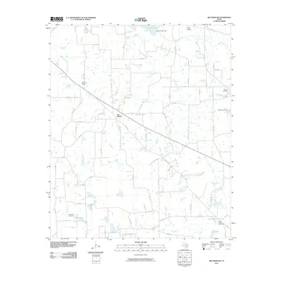
2010 Map of Ben Wheeler
USGS Topo · Published 2010About this map
Ben Wheeler serves as the central hub of this East Texas landscape, where a network of county roads radiates through the wooded terrain of Van Zandt County. The map documents a rural environment defined by its water resources, from the upper reaches of the Neches River to numerous small reservoirs like Rhine Lake and Mitchell Lake. These water bodies, often formed by private impoundments such as the Cantrell Lake Dam and Payne Ranch Lake Dam, illustrate the region's reliance on managed water for ranching and recreation. Genealogy researchers will find significant markers of the community's history in the Marvin Chapel Cemetery to the north and the Prairie Springs Cemetery to the west. The drainage patterns of Prairie Creek and Slater Creek carve through the countryside, punctuated by landmarks like Carter Spring, reflecting the area's natural spring-fed hydrology before the intensification of modern development.
Find a feature on this map
69 named features on this map. Tap any name to fly to it.
Don’t see what you’re looking for? This feature index may not catch every label — zoom into the map to look around manually.
Map Details
Editions of this 2010 Ben Wheeler Map
This is the sole edition of this map. No revisions or reprints were ever made.
Other maps of this area

1948 · Brownsboro
USGS Topo · 1:62,500

1948 · Martins Mill
USGS Topo · 1:62,500

1949 · Martins Mill
USGS Topo · 1:62,500

1949 · Brownsboro
USGS Topo · 1:62,500

1956 · Tyler
USGS Topo · 1:250,000

1959 · Van
USGS Topo · 1:24,000

1959 · Van Lake
USGS Topo · 1:24,000

1959 · Grand Saline
USGS Topo · 1:62,500
1962 · Canton
USGS Topo · 1:24,000

1984 · Tyler
USGS Topo · 1:250,000