
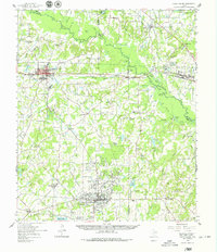
1959 Map of Grand Saline
USGS Topo · Published 1961About this map
The Sabine River snakes through the northern portion of this 1959 survey, defining a landscape at the junction of Van Zandt, Smith, and Wood counties. The Texas and Pacific Railroad serves as a primary industrial corridor, connecting the established settlements of Grand Saline and Mineola. This region is defined by the extraction of natural resources, prominently displayed through the extensive Van Oil Field and the Nolan Edwards Oil Field, which underscore the era's energy-driven economy. Smaller communities and rural landmarks like Golden, Garden Valley, and Jamestown are scattered across the terrain, interspersed with local institutions such as Union Chapel and Providence Sch. The presence of Collins Ferry on the river and numerous named water bodies like Silver Lake and Lake Louise reflect a landscape where water and rail dictated the flow of commerce and settlement long before modern highway expansion dominated the interior of East Texas.
Find a feature on this map
83 named features on this map. Tap any name to fly to it.
Don’t see what you’re looking for? This feature index may not catch every label — zoom into the map to look around manually.
Map Details
Editions of this 1959 Grand Saline Map
2 editions found
Other maps of this area

1948 · Tyler
USGS Topo · 1:62,500

1948 · Brownsboro
USGS Topo · 1:62,500

1948 · Martins Mill
USGS Topo · 1:62,500

1949 · Tyler
USGS Topo · 1:62,500

1949 · Martins Mill
USGS Topo · 1:62,500

1949 · Brownsboro
USGS Topo · 1:62,500

1956 · Tyler
USGS Topo · 1:250,000

1956 · Emory
USGS Topo · 1:62,500

1958 · Alba
USGS Topo · 1:24,000

1959 · Calvary
USGS Topo · 1:24,000