
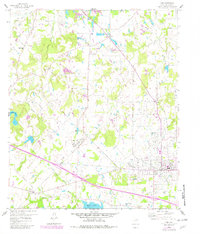
1959 Map of Van
USGS Topo · Published 1960About this map
Van stands as the primary hub in this late 1950s survey of eastern Van Zandt County, reflecting a landscape defined by both agriculture and industrial activity. A sprawling Tank Farm and the presence of numerous salt-related features, such as Magers Pond (Salt) and Tunnell Pond (Salt), indicate the importance of local extraction and storage industries during this era. The community is connected to the wider region by the Texas Short Line railroad, which cuts through the central terrain alongside numerous small settlements like Colfax and Owlett Green.
Find a feature on this map
31 named features on this map. Tap any name to fly to it.
Don’t see what you’re looking for? This feature index may not catch every label — zoom into the map to look around manually.
Map Details
Editions of this 1959 Van Map
2 editions found
Other maps of this area

1948 · Brownsboro
USGS Topo · 1:62,500

1948 · Martins Mill
USGS Topo · 1:62,500

1949 · Martins Mill
USGS Topo · 1:62,500

1949 · Brownsboro
USGS Topo · 1:62,500

1956 · Tyler
USGS Topo · 1:250,000

1959 · Golden
USGS Topo · 1:24,000

1959 · Grand Saline
USGS Topo · 1:24,000

1959 · Van Lake
USGS Topo · 1:24,000

1959 · Grand Saline
USGS Topo · 1:62,500
1962 · Canton
USGS Topo · 1:24,000