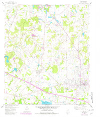
1959 Map of Van
USGS Topo · Published 1982About this map
The Van Oil Field dominates this late-1950s landscape, illustrating the industrial infrastructure of East Texas with its extensive Tank Farm and numerous pipelines. Centered on the town of Van, the map captures a transition period where rural community life and heavy industry intersect. Small settlements like Pruitt, Colfax, and Owlett Green are interconnected by a network of roads that wind through the drainage basins of Dry Creek and Grand Saline Creek.
Find a feature on this map
32 named features on this map. Tap any name to fly to it.
Don’t see what you’re looking for? This feature index may not catch every label — zoom into the map to look around manually.
Map Details
Editions of this 1959 Van Map
2 editions found
Other maps of this area

1948 · Brownsboro
USGS Topo · 1:62,500

1948 · Martins Mill
USGS Topo · 1:62,500

1949 · Martins Mill
USGS Topo · 1:62,500

1949 · Brownsboro
USGS Topo · 1:62,500

1956 · Tyler
USGS Topo · 1:250,000

1959 · Golden
USGS Topo · 1:24,000

1959 · Grand Saline
USGS Topo · 1:24,000

1959 · Van
USGS Topo · 1:24,000

1959 · Van Lake
USGS Topo · 1:24,000

1959 · Grand Saline
USGS Topo · 1:62,500