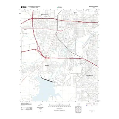
2010 Map of Benbrook
USGS Topo · Published 2010About this map
Benbrook Lake and the Benbrook Dam anchor the southern portion of this landscape, where the Clear Fork Trinity River is harnessed for flood control and recreation. The 2010 geography reveals a dense suburban and industrial interface on the western edge of Fort Worth, characterized by significant transportation corridors like the W Loop 820 S and the sprawling rail infrastructure at Lancaster Yards.
Find a feature on this map
41 named features on this map. Tap any name to fly to it.
Don’t see what you’re looking for? This feature index may not catch every label — zoom into the map to look around manually.
Map Details
Editions of this 2010 Benbrook Map
This is the sole edition of this map. No revisions or reprints were ever made.
Other maps of this area

1891 · Weatherford
USGS Topo · 1:125,000

1893 · Weatherford
USGS Topo · 1:125,000

1894 · Fort Worth
USGS Topo · 1:125,000

1932 · Springtown
USGS Topo · 1:62,500

1954 · Dallas
USGS Topo · 1:250,000

1955 · Haltom City
USGS Topo · 1:24,000

1955 · Burleson
USGS Topo · 1:24,000

1955 · Aledo
USGS Topo · 1:24,000

1955 · Primrose
USGS Topo · 1:24,000
1955 · Cresson
USGS Topo · 1:24,000