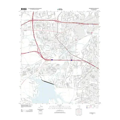
2012 Map of Benbrook
USGS Topo · Published 2012About this map
Clear Fork Trinity River winds through the heart of this Tarrant County landscape, serving as a geographic anchor for the suburban and industrial developments of West Fort Worth. The map illustrates a complex transportation web, from the high-capacity SW Loop 820 and W Fwy corridors to the specialized rail infrastructure of the Lancaster Yards. In the northern reaches, the enclave of Westover Hills contrasts with the western settlements of Westland and Hillcrest. Natural and managed water features define the local character, including the sprawling Benbrook Lake at the southern edge and the smaller Lake Como, which is accompanied by the Lake Como Cem. Local landmarks such as the Hillcrest Observation Point and the Edworth Beauty Sch provide specific points of interest for those researching the community's modern layout and social infrastructure during the early 2010s.
Find a feature on this map
23 named features on this map. Tap any name to fly to it.
Don’t see what you’re looking for? This feature index may not catch every label — zoom into the map to look around manually.
Map Details
Editions of this 2012 Benbrook Map
This is the sole edition of this map. No revisions or reprints were ever made.
Other maps of this area

1891 · Weatherford
USGS Topo · 1:125,000

1893 · Weatherford
USGS Topo · 1:125,000

1894 · Fort Worth
USGS Topo · 1:125,000

1932 · Springtown
USGS Topo · 1:62,500

1954 · Dallas
USGS Topo · 1:250,000

1955 · Haltom City
USGS Topo · 1:24,000

1955 · Burleson
USGS Topo · 1:24,000

1955 · Aledo
USGS Topo · 1:24,000

1955 · Primrose
USGS Topo · 1:24,000
1955 · Cresson
USGS Topo · 1:24,000