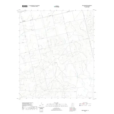
2019 Map of Bench Mountain
USGS Topo · Published 2019About this map
Champion and its nearby Champion Cem anchor the northwest corner of this West Texas landscape, where the plateaus and drainages of Nolan County define the local geography. The area is dominated by the prominent elevation of Bench Mtn, a central landmark surrounded by a network of seasonal watercourses. These include the S Fork Champion Cr and Barnett Cr, which carve through the terrain as they flow toward the south and west.
Find a feature on this map
22 named features on this map. Tap any name to fly to it.
Don’t see what you’re looking for? This feature index may not catch every label — zoom into the map to look around manually.
Map Details
Editions of this 2019 Bench Mountain Map
This is the sole edition of this map. No revisions or reprints were ever made.
Other maps of this area

1893 · Sweetwater
USGS Topo · 1:125,000

1954 · Big Spring
USGS Topo · 1:250,000

1958 · Big Spring
USGS Topo · 1:250,000

1959 · Dam Draw
USGS Topo · 1:24,000

1969 · Baumann School
USGS Topo · 1:24,000

1969 · Bench Mountain
USGS Topo · 1:24,000

1969 · Loraine
USGS Topo · 1:24,000

1969 · Maryneal
USGS Topo · 1:24,000
1969 · Dew Drop Creek
USGS Topo · 1:24,000

1969 · Roscoe
USGS Topo · 1:24,000