
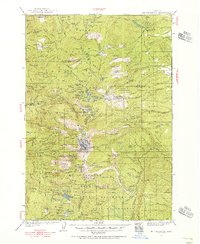
1958 Map of Bend
USGS Topo · Published 1958About this map
The Warm Springs Indian Reservation and the dramatic volcanic peaks of the Cascade Range dominate this mid-century landscape. Centered on the growing agricultural and timber hubs of Bend, Redmond, and Prineville, the map highlights a region transitioning into a modern recreation and ranching center. The rugged canyons of the Deschutes River and Crooked River converge near Lake Billy Chinook, while the towering summits of Mount Jefferson and the Three Sisters — North Sister, Middle Sister, and South Sister — define the western horizon. Transportation is anchored by the Oregon Trunk Railroad and Great Northern Railway, which follow the river corridors to move goods across the high desert. Smaller settlements like Metolius, Alfalfa, and Post are recorded alongside vital irrigation works like the Ochoco Reservoir, illustrating the massive engineering efforts required to sustain life in the arid interior of Central Oregon.
Find a feature on this map
85 named features on this map. Tap any name to fly to it.
Don’t see what you’re looking for? This feature index may not catch every label — zoom into the map to look around manually.
Map Details
Editions of this 1958 Bend Map
This is the sole edition of this map. No revisions or reprints were ever made.
Other maps of this area

1916 · Estacada
USGS Topo · 1:125,000

1916 · Condon
USGS Topo · 1:125,000

1924 · Mount Hood
USGS Topo · 1:125,000

1925 · Waldo Lake
USGS Topo · 1:125,000

1926 · Mitchell
USGS Topo · 1:125,000

1926 · Bend
USGS Topo · 1:125,000

1927 · Mount Hood
USGS Topo · 1:125,000
1927 · Mt. Jefferson
USGS Topo · 1:125,000

1928 · Madras
USGS Topo · 1:125,000
1929 · Mill City
USGS Topo · 1:125,000