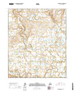
2017 Map of Bendeleben A-3 SE
USGS Topo · Published 2017About this map
The Seward Peninsula interior is defined here by a dense network of meandering waterways and wetlands, showing the landscape as it appeared in the early 21st century. The Pargon River flows across the southern portion of the sheet, while the Fish River dominates the eastern and northern drainage patterns. These riparian corridors, including the winding Boston Creek, are the primary geographical markers in an area otherwise characterized by small ponds and shifting lake beds.
Find a feature on this map
15 named features on this map. Tap any name to fly to it.
Don’t see what you’re looking for? This feature index may not catch every label — zoom into the map to look around manually.
Map Details
Editions of this 2017 Bendeleben A-3 SE Map
This is the sole edition of this map. No revisions or reprints were ever made.
Other maps of this area

1950 · Bendeleben A-3
USGS Topo · 1:63,360

1950 · Bendeleben A-2
USGS Topo · 1:63,360

1950 · Solomon D-2
USGS Topo · 1:63,360

1950 · Bendeleben
USGS Topo · 1:250,000

1950 · Solomon D-3
USGS Topo · 1:63,360

1950 · Solomon
USGS Topo · 1:250,000

1951 · Bendeleben
USGS Topo · 1:250,000

1951 · Solomon
USGS Topo · 1:250,000

1964 · Bendeleben
USGS Topo · 1:250,000
2017 · Solomon D-2 NW
USGS Topo · 1:25,000