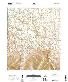
2017 Map of Solomon D-2 NW
USGS Topo · Published 2017About this map
Rathlatulik River flows through this Seward Peninsula landscape, carving a meandering path through the northern half of the region. The terrain is defined by its complex hydrology, where the Etchepuk River and several smaller tributaries like Omilak Cr and Cache Cr drain the rising elevations found in the southern sections. This 2017 survey by the U.S. Geological Survey illustrates the transition from the low-lying wetlands and river bends to the more prominent topographic contours of the south, specifically near Dry Canyon Cr. The map provides a clear view of the public land subdivisions, including the corners of T6S R21W and T7S R20W, reflecting the administrative structure of this part of the Nome Census Area.
Find a feature on this map
9 named features on this map. Tap any name to fly to it.
Don’t see what you’re looking for? This feature index may not catch every label — zoom into the map to look around manually.
Map Details
Editions of this 2017 Solomon D-2 NW Map
This is the sole edition of this map. No revisions or reprints were ever made.
Other maps of this area

1950 · Bendeleben A-3
USGS Topo · 1:63,360

1950 · Bendeleben A-2
USGS Topo · 1:63,360

1950 · Solomon D-2
USGS Topo · 1:63,360

1950 · Bendeleben
USGS Topo · 1:250,000

1950 · Solomon D-3
USGS Topo · 1:63,360

1950 · Solomon
USGS Topo · 1:250,000

1951 · Bendeleben
USGS Topo · 1:250,000

1951 · Solomon
USGS Topo · 1:250,000

1964 · Bendeleben
USGS Topo · 1:250,000
2014 · Solomon D-2 SE
USGS Topo · 1:25,000