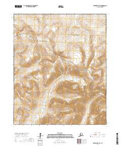
2017 Map of Bendeleben B-3 SE
USGS Topo · Published 2017About this map
Bering Land Bridge National Preserve occupies a significant portion of this interior landscape on the Seward Peninsula, where high elevations and complex drainage systems define the geography. The terrain is anchored by Mt Boyan in the northwest, rising above a network of waterways that eventually feed into the Bering Sea. The hydrological pattern is particularly distinct, featuring the meandering Fish River and the northern flow of the S Fork Kuzitrin River, while smaller tributaries like Caviar Cr cut through the steep contour gradients. This 2017 study illustrates a region defined by its protected status and natural boundaries rather than permanent settlements, providing a clear view of the wilderness character and the watershed divides that dictate movement across this part of the Alaskan bush.
Find a feature on this map
12 named features on this map. Tap any name to fly to it.
Don’t see what you’re looking for? This feature index may not catch every label — zoom into the map to look around manually.
Map Details
Editions of this 2017 Bendeleben B-3 SE Map
This is the sole edition of this map. No revisions or reprints were ever made.
Other maps of this area

1950 · Bendeleben B-2
USGS Topo · 1:63,360

1950 · Bendeleben A-3
USGS Topo · 1:63,360

1950 · Bendeleben A-2
USGS Topo · 1:63,360

1950 · Bendeleben B-3
USGS Topo · 1:63,360

1950 · Bendeleben
USGS Topo · 1:250,000

1951 · Bendeleben
USGS Topo · 1:250,000

1964 · Bendeleben
USGS Topo · 1:250,000
2017 · Bendeleben A-2 NW
USGS Topo · 1:25,000
2017 · Bendeleben B-2 SW
USGS Topo · 1:25,000
2017 · Bendeleben B-2 NW
USGS Topo · 1:25,000