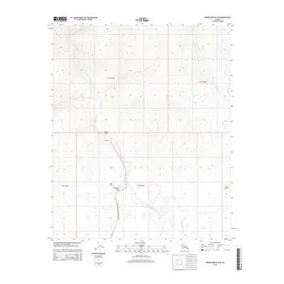
2014 Map of Bendeleben B-6 NE
USGS Topo · Published 2014About this map
The Kougarok River dominates this northern landscape, winding through a terrain defined by seasonal waterways and mining-era infrastructure. The presence of a Roadhouse and the Quartz Creek (Kougarok) Airport underscores the critical importance of these remote hubs for transit and supply. Local transit is facilitated by the Kougarok Road/Nome-Taylor Highway, a lifeline connecting these isolated outposts. To the east, the landscape is etched by named tributaries including Delome Cr and Garfield Cr, while the southern reaches feature Minguk Lake and drainage from N Fork Quartz Cr. The naming of Mauze Gulch and Ryan Gulch suggests a history of local exploration and land use, likely tied to the region's long-standing connection to resource extraction and backcountry navigation in the Unorganized Borough.
Find a feature on this map
23 named features on this map. Tap any name to fly to it.
Don’t see what you’re looking for? This feature index may not catch every label — zoom into the map to look around manually.
Map Details
Editions of this 2014 Bendeleben B-6 NE Map
This is the sole edition of this map. No revisions or reprints were ever made.
Other maps of this area

1950 · Bendeleben C-5
USGS Topo · 1:63,360

1950 · Bendeleben B-5
USGS Topo · 1:63,360

1950 · Bendeleben B-6
USGS Topo · 1:63,360

1950 · Bendeleben C-6
USGS Topo · 1:63,360

1950 · Bendeleben
USGS Topo · 1:250,000

1951 · Bendeleben
USGS Topo · 1:250,000

1964 · Bendeleben
USGS Topo · 1:250,000
2014 · Bendeleben C-5 SW
USGS Topo · 1:25,000
2014 · Bendeleben C-6 SW
USGS Topo · 1:25,000
2014 · Bendeleben B-6 NW
USGS Topo · 1:25,000