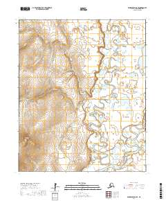
2017 Map of Bendeleben B-6 SE
USGS Topo · Published 2017About this map
Seward Peninsula interior terrain dominates this part of the Nome Census Area, where the Kougarok Road / Nome-Taylor Highway provides the primary overland artery through a landscape defined by complex river systems. The settlement of Dahl is situated in the north near the confluence of Dahl Cr and Quartz Cr, marking a point of human activity in an area otherwise characterized by drainage basins and elevated landmarks. The meandering Kougarok River and Kuzitrin River create intricate hydrological patterns across the eastern and southern portions of the sheet. Notable topographical features such as Coffee Dome and Wonder Gulch interrupt the drainages of Coffee Cr and Dome Cr, illustrating the relationship between the uplands and the many named tributaries like Whelan Cr and Bunker Hill Cr that feed the region's larger rivers.
Find a feature on this map
29 named features on this map. Tap any name to fly to it.
Don’t see what you’re looking for? This feature index may not catch every label — zoom into the map to look around manually.
Map Details
Editions of this 2017 Bendeleben B-6 SE Map
This is the sole edition of this map. No revisions or reprints were ever made.
Other maps of this area

1950 · Bendeleben A-6
USGS Topo · 1:63,360

1950 · Bendeleben B-5
USGS Topo · 1:63,360

1950 · Bendeleben B-6
USGS Topo · 1:63,360

1950 · Bendeleben A-5
USGS Topo · 1:63,360

1950 · Bendeleben
USGS Topo · 1:250,000

1951 · Bendeleben
USGS Topo · 1:250,000

1964 · Bendeleben
USGS Topo · 1:250,000
2014 · Bendeleben B-6 NE
USGS Topo · 1:25,000
2014 · Bendeleben B-6 NW
USGS Topo · 1:25,000
2017 · Bendeleben A-6 NW
USGS Topo · 1:25,000