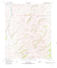
1950 Map of Bendeleben C-1
USGS Topo · Published 1981About this map
The Continental Divide cuts across this high-latitude terrain, marking a watershed boundary between the numerous creek systems draining the Seward Peninsula. A distinct signature of early 20th-century hydraulic mining is visible in the Candle Ditch, an extensive water conveyance system winding through the northeastern drainage near Bonanza Creek. This infrastructure supported placer mining operations in the Candle district, further evidenced by a nearby Tel Line and isolated structures like a solitary Cabin. The western edge is defined by the winding course of the Kuguruk River and its tributaries, including Holtz Creek and Independence Creek. From the summit of Monument Mountain to the southern Kiwalik Mountain, the landscape is a complex network of gold-bearing prospects such as Glacier Creek, Eldorado Creek, and First Chance Cr. A remote Landing Strip provides one of the few points of access to this interior wilderness.
Find a feature on this map
33 named features on this map. Tap any name to fly to it.
Don’t see what you’re looking for? This feature index may not catch every label — zoom into the map to look around manually.
Map Details
Editions of this 1950 Bendeleben C-1 Map
3 editions found
Other maps of this area

1950 · Bendeleben C-1
USGS Topo · 1:63,360

1950 · Bendeleben B-2
USGS Topo · 1:63,360

1950 · Bendeleben C-2
USGS Topo · 1:63,360

1950 · Bendeleben B-1
USGS Topo · 1:63,360

1950 · Bendeleben D-2
USGS Topo · 1:63,360

1950 · Bendeleben
USGS Topo · 1:250,000

1950 · Bendeleben D-1
USGS Topo · 1:63,360

1950 · Candle B-6
USGS Topo · 1:63,360

1950 · Candle C-6
USGS Topo · 1:63,360

1951 · Candle
USGS Topo · 1:250,000