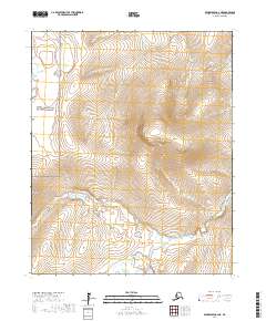
2017 Map of Bendeleben C-2 NE
USGS Topo · Published 2017About this map
Bering Land Bridge National Preserve occupies the western reaches of this landscape on the Seward Peninsula, where the interior wilderness remains largely untouched by modern infrastructure. The Kugruk River meanders through the southern and eastern portions of the map, carving a path through the tundra and upland terrain. This 2017 survey reflects the remote character of the Northwest Arctic Borough, highlighting the natural drainage patterns and topographical contours that define the region. With no established roads or settlements printed on the sheet, the map serves as a study of raw geography and protected federal lands in the Alaskan arctic.
Find a feature on this map
7 named features on this map. Tap any name to fly to it.
Don’t see what you’re looking for? This feature index may not catch every label — zoom into the map to look around manually.
Map Details
Editions of this 2017 Bendeleben C-2 NE Map
This is the sole edition of this map. No revisions or reprints were ever made.
Other maps of this area

1950 · Bendeleben C-1
USGS Topo · 1:63,360

1950 · Bendeleben C-2
USGS Topo · 1:63,360

1950 · Bendeleben D-2
USGS Topo · 1:63,360

1950 · Bendeleben
USGS Topo · 1:250,000

1950 · Bendeleben D-1
USGS Topo · 1:63,360

1951 · Bendeleben
USGS Topo · 1:250,000

1964 · Bendeleben
USGS Topo · 1:250,000
2017 · Bendeleben C-2 SE
USGS Topo · 1:25,000
2017 · Bendeleben C-1 NW
USGS Topo · 1:25,000
2017 · Bendeleben D-2 SE
USGS Topo · 1:25,000