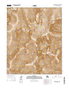
2014 Map of Bendeleben C-5 NW
USGS Topo · Published 2014About this map
The Bering Land Bridge National Preserve occupies much of this high-latitude Alaskan landscape, protecting a vast stretch of the Seward Peninsula. The terrain is defined by a dense network of drainage systems, including the headwaters of Skookum Cr and Eldorado Cr. These watercourses reflect the complex hydrology of the subarctic tundra, where seasonal runoff carves distinct paths through the topographic relief. Local history and prospectors' nomenclature are evident in the naming of smaller tributaries like Lucky Cr, Harris Cr, and Shasta Cr. The mapping of these remote corridors, including Alder Cr and Lorna Cr, provides critical geographic data for understanding this protected wilderness area near Nome, where natural boundaries often follow the contours of the watershed.
Find a feature on this map
15 named features on this map. Tap any name to fly to it.
Don’t see what you’re looking for? This feature index may not catch every label — zoom into the map to look around manually.
Map Details
Editions of this 2014 Bendeleben C-5 NW Map
This is the sole edition of this map. No revisions or reprints were ever made.
Other maps of this area

1950 · Bendeleben C-5
USGS Topo · 1:63,360

1950 · Bendeleben C-6
USGS Topo · 1:63,360

1950 · Bendeleben D-6
USGS Topo · 1:63,360

1950 · Bendeleben D-5
USGS Topo · 1:63,360

1950 · Bendeleben
USGS Topo · 1:250,000

1951 · Bendeleben
USGS Topo · 1:250,000

1964 · Bendeleben
USGS Topo · 1:250,000
2014 · Bendeleben C-5 SW
USGS Topo · 1:25,000
2014 · Bendeleben D-6 SE
USGS Topo · 1:25,000
2014 · Bendeleben D-5 SW
USGS Topo · 1:25,000