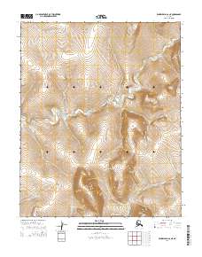
2014 Map of Bendeleben C-6 NE
USGS Topo · Published 2014About this map
The Continental Divide winds through this northern landscape on the Seward Peninsula, separating the complex drainage networks of the Nome region. This 2014 survey captures a terrain defined by high summits like Black Dome and Harris Dome, where the headwaters of numerous creeks begin their descent. To the north, the Right Fork Macklin Cr and Macklin Cr carve through the high ground, while the eastern reaches are defined by the branching paths of Salmon Cr and Taylor Cr. The map illustrates a remote wilderness where geographic features are the primary landmarks, such as Goose Gulch and the narrow valley of Jim Cr. The distribution of these waterways and peaks reflects the raw physical geography of the Alaskan interior, providing a detailed record of the hydrography near the boundary of T4N R29W and T3N R28W.
Find a feature on this map
22 named features on this map. Tap any name to fly to it.
Don’t see what you’re looking for? This feature index may not catch every label — zoom into the map to look around manually.
Map Details
Editions of this 2014 Bendeleben C-6 NE Map
This is the sole edition of this map. No revisions or reprints were ever made.
Other maps of this area

1950 · Bendeleben C-5
USGS Topo · 1:63,360

1950 · Bendeleben C-6
USGS Topo · 1:63,360

1950 · Bendeleben D-6
USGS Topo · 1:63,360

1950 · Bendeleben D-5
USGS Topo · 1:63,360

1950 · Bendeleben
USGS Topo · 1:250,000

1951 · Bendeleben
USGS Topo · 1:250,000

1964 · Bendeleben
USGS Topo · 1:250,000
2014 · Bendeleben D-6 SW
USGS Topo · 1:25,000
2014 · Bendeleben C-6 NW
USGS Topo · 1:25,000
2014 · Bendeleben C-5 SW
USGS Topo · 1:25,000