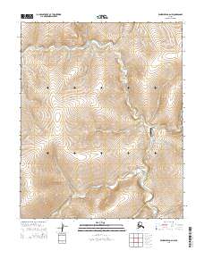
2014 Map of Bendeleben C-6 NW
USGS Topo · Published 2014About this map
Taylor serves as the focal point of this remote interior Alaska landscape, situated where several creeks converge before joining the southward flow of the Kougarok River. The settlement's isolation is underscored by the presence of the Taylor Airport, a vital transportation link in a region dominated by an intricate drainage network. Numerous watercourses, many bearing prospector-era names like Homestake Cr, Eldorado Cr, and Mastodon Cr, carve through the terrain, suggesting a history tied to mineral exploration.
Find a feature on this map
25 named features on this map. Tap any name to fly to it.
Don’t see what you’re looking for? This feature index may not catch every label — zoom into the map to look around manually.
Map Details
Editions of this 2014 Bendeleben C-6 NW Map
This is the sole edition of this map. No revisions or reprints were ever made.
Other maps of this area

1950 · Bendeleben C-6
USGS Topo · 1:63,360

1950 · Bendeleben D-6
USGS Topo · 1:63,360

1950 · Teller
USGS Topo · 1:250,000

1950 · Bendeleben
USGS Topo · 1:250,000

1950 · Teller D-1
USGS Topo · 1:63,360
1950 · Teller C-1
USGS Topo · 1:63,360

1951 · Bendeleben
USGS Topo · 1:250,000

1951 · Teller
USGS Topo · 1:250,000

1957 · Teller
USGS Topo · 1:250,000

1958 · Teller
USGS Topo · 1:250,000