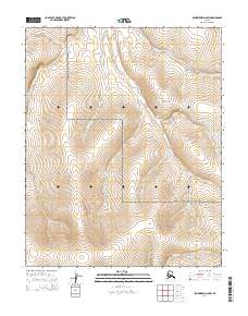
2014 Map of Bendeleben D-6 SW
USGS Topo · Published 2014About this map
The Bering Land Bridge National Preserve encompasses the majority of this Seward Peninsula landscape, protecting a remote wilderness defined by its complex drainage systems. Several prominent waterways, including Mukluk Cr, Schlitz Cr, and Bella Cr, carve through the terrain as they flow toward the interior. The presence of Hot Springs Cr in the northeast quadrant suggests the geothermal activity characteristic of this volcanic region, while names like Reindeer Cr provide a linguistic link to the traditional land use and herding history of the area. This 2014 survey serves as a detailed baseline for the natural hydrography of the Bendeleben region, documenting the intricate paths of Star Cr, Preston Cr, and Macklin Cr across the tundra.
Find a feature on this map
17 named features on this map. Tap any name to fly to it.
Don’t see what you’re looking for? This feature index may not catch every label — zoom into the map to look around manually.
Map Details
Editions of this 2014 Bendeleben D-6 SW Map
This is the sole edition of this map. No revisions or reprints were ever made.
Other maps of this area

1950 · Bendeleben C-6
USGS Topo · 1:63,360

1950 · Bendeleben D-6
USGS Topo · 1:63,360

1950 · Teller
USGS Topo · 1:250,000

1950 · Bendeleben
USGS Topo · 1:250,000

1950 · Teller D-1
USGS Topo · 1:63,360
1950 · Teller C-1
USGS Topo · 1:63,360

1951 · Bendeleben
USGS Topo · 1:250,000

1951 · Teller
USGS Topo · 1:250,000

1957 · Teller
USGS Topo · 1:250,000

1958 · Teller
USGS Topo · 1:250,000