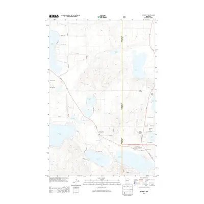
2013 Map of Benedict
USGS Topo · Published 2013About this map
The settlement of Benedict sits at the heart of this Northwoods landscape, where the Kabekona River winds toward the expansive waters of Leech Lake. This 2013 survey reveals a region defined by its complex hydrography and recreation-based infrastructure, situated along the boundary of Hubbard Co and Cass Co. The southern portion of the map is dominated by the Chippewa National Forest, while the northern reaches feature a cluster of glacial lakes including Garfield Lake, Spring Lake, and Swamp Lake. Significant local landmarks like the Golden Gate Cem and Walker Municipal Airport provide essential points of reference for genealogists and local historians. The presence of the Walker Rest Area and several modern developments such as the Wedgewood Golf Course and Water's Edge RV Park reflect the area's continued evolution as a destination for seasonal travelers and residents alike.
Find a feature on this map
46 named features on this map. Tap any name to fly to it.
Don’t see what you’re looking for? This feature index may not catch every label — zoom into the map to look around manually.
Map Details
Editions of this 2013 Benedict Map
This is the sole edition of this map. No revisions or reprints were ever made.
Other maps of this area

1954 · Bemidji
USGS Topo · 1:250,000

1957 · Bemidji
USGS Topo · 1:250,000

1958 · Bemidji
USGS Topo · 1:250,000

1968 · Guthrie
USGS Topo · 1:24,000

1972 · Steamboat Bay
USGS Topo · 1:24,000
1972 · East Crooked Lake
USGS Topo · 1:24,000

1972 · Benedict
USGS Topo · 1:24,000

1972 · Laporte
USGS Topo · 1:24,000

1972 · Pike Bay
USGS Topo · 1:24,000
1972 · Akeley
USGS Topo · 1:24,000