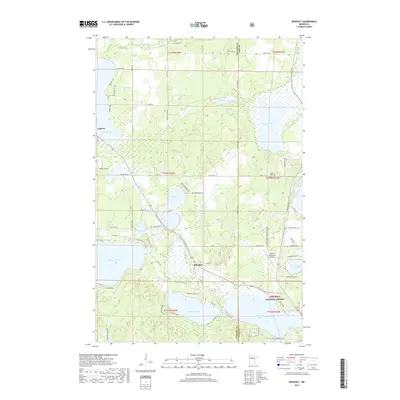
2019 Map of Benedict
USGS Topo · Published 2019About this map
Laporte and the smaller settlement of Benedict sit within a landscape of interconnected glacial lakes and wetlands along the Hubbard and Cass county line. The northern reaches of the Chippewa National Forest dominate the southern portion of the map, where the Kabekona River flows into the expansive Kabekona Bay of Leech Lake. This 2019 survey shows the modern balance of seasonal recreation and residential growth, with the Paul Bunyan State Trl cutting a path through the woods past Horseshoe Lake and Oak Lake.
Find a feature on this map
63 named features on this map. Tap any name to fly to it.
Don’t see what you’re looking for? This feature index may not catch every label — zoom into the map to look around manually.
Map Details
Editions of this 2019 Benedict Map
This is the sole edition of this map. No revisions or reprints were ever made.
Other maps of this area

1954 · Bemidji
USGS Topo · 1:250,000

1957 · Bemidji
USGS Topo · 1:250,000

1958 · Bemidji
USGS Topo · 1:250,000

1968 · Guthrie
USGS Topo · 1:24,000

1972 · Steamboat Bay
USGS Topo · 1:24,000
1972 · East Crooked Lake
USGS Topo · 1:24,000

1972 · Benedict
USGS Topo · 1:24,000

1972 · Laporte
USGS Topo · 1:24,000

1972 · Pike Bay
USGS Topo · 1:24,000
1972 · Akeley
USGS Topo · 1:24,000