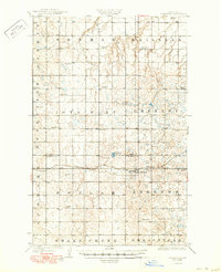
1929 Map of Benedict
USGS Topo · Published 1950About this map
Benedict serves as the central hub of this prairie landscape, established along the Minneapolis St Paul and Sault Ste Marie railroad line. Surveyed in the mid-1920s, the map reveals a systematic rural organization across the border of Ward and McLean Counties. The terrain is characterized by broad glacial features including Iota Flat and Andrews, punctuated by small prairie potholes and water bodies like McMann Lake. This era shows a high density of rural education, with numerous numbered schoolhouses such as School No 1 and School No 4 distributed across townships like Brillian and Greeley. The presence of Oak Creek and the drainage toward Snake Creek suggests the agricultural importance of the local watershed during this period of North Dakota's development.
Find a feature on this map
17 named features on this map. Tap any name to fly to it.
Don’t see what you’re looking for? This feature index may not catch every label — zoom into the map to look around manually.
Map Details
Editions of this 1929 Benedict Map
3 editions found
Other maps of this area

1922 · Garrison
USGS Topo · 1:62,500

1928 · Minot
USGS Topo · 1:62,500

1929 · Sawyer
USGS Topo · 1:62,500

1929 · Coleharbor
USGS Topo · 1:62,500

1929 · Benedict
USGS Topo · 1:62,500

1929 · Kongsberg
USGS Topo · 1:62,500

1947 · Turtle Lake
USGS Topo · 1:62,500

1948 · Velva
USGS Topo · 1:62,500

1948 · Sawyer
USGS Topo · 1:24,000

1949 · Sawyer
USGS Topo · 1:24,000